
Map published in Atlas of Near East, Brill, Amsterdam, 2017
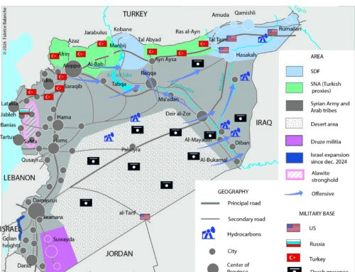
On December 14, 1981, Israel officially annexed the Golan Heights occupied since 1967 by its army. This measure complicates its possible return to Syria because it would require a 2/3 majority in the Knesset or 65% of the votes in a referendum. This annexation is not recognized by the international community which considers that the Golan is an occupied territory in the same way as the West Bank and Gaza, but unlike the Palestinian territories which do not have a state, the Golan belongs to a state sovereign. The Syrian population of the Golan refused the Israeli nationality which was offered to them and continues to show its attachment to Syria. The 5,000 Syrians who remained in the Golan, out of a population of around 80,000 people, now number 22,000 due to combat demographics. They are confined to four villages north of the plateau, while 95% of the Golan area is occupied by 20,000 settlers grouped in 34 settlements founded in place of destroyed Syrian villages. But unlike the West Bank, colonization is stalling due to the distance from major urban centers and fears about its retrocession to Syria, even though there is an ambitious plan to settle 200,000 Jewish settlers there.
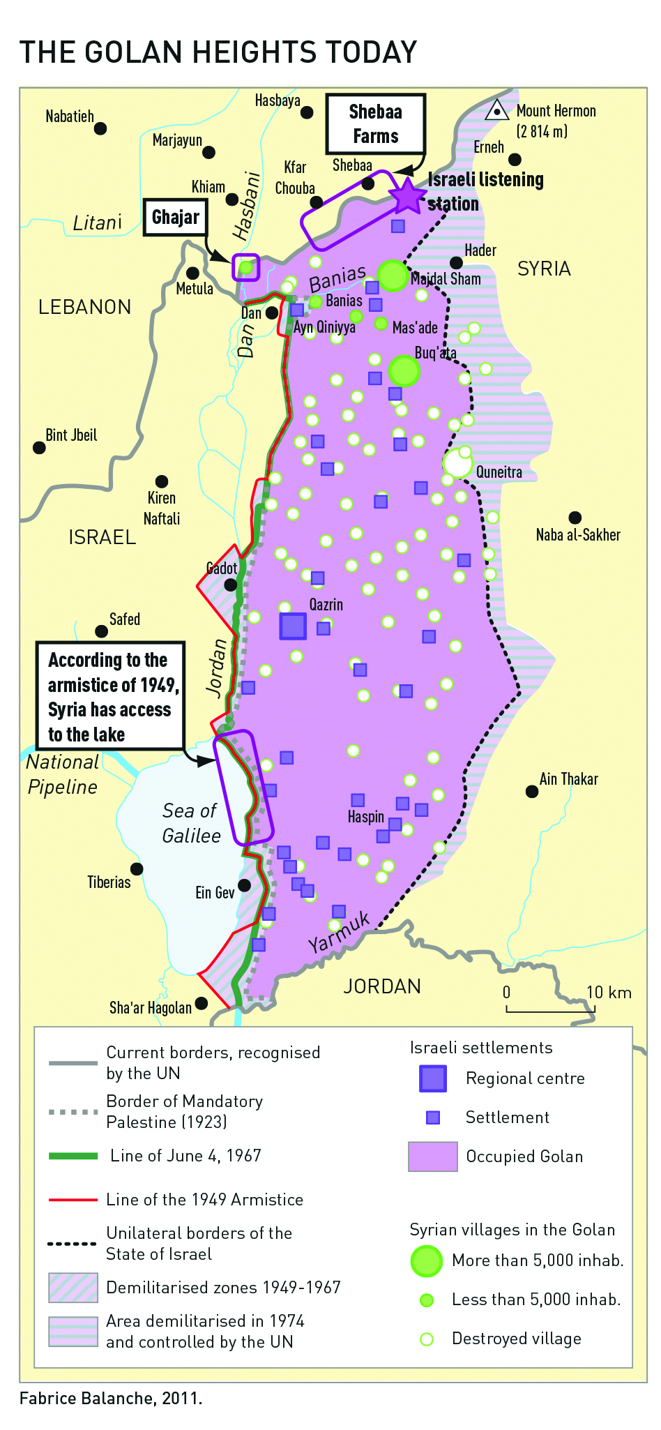
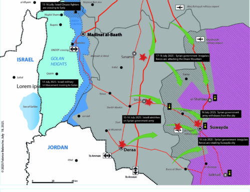
The Golan is presented by Israel as essential to its security. On the one hand this plateau overlooks the north of Israel and constitutes a natural barrier to prevent any Syrian offensive, on the other hand the Israeli surveillance stations control the south of Syria. On the other hand, the Golan watershed feeds Lake Tiberias where Israel takes more than a third of its water consumption. In March 2000, Israeli Prime Minister Ehud Barak and Syrian President Hafez El Assad seemed close to a peace agreement in exchange for the return of the Golan to Syria on the model of Egypt’s Sinai. But the negotiations essentially failed over the course of the border: ten meters which gave Syria access to Lake Tiberias. This detail is crucial as to the status of Lake Tiberias because it makes it an international lake, moreover with most of its impluvium in Syrian territory, Israel should therefore officially negotiate the use of water with Syria.
The boundary between the French and British mandates was difficult to draw in the area of Lake Tiberias precisely because of Zionist claims. The Sykes Picot agreements shared Lake Tiberias, then the 1923 agreements pushed the border 10 meters east of the lake so that it was entirely within Palestine, leaving only fishing and navigation rights to Syria. During the first Arab-Israeli war, Syria conquered the eastern shore of the lake which became the armistice line of 1949. The demilitarized zones were gradually reoccupied by the belligerents, but Syria retained the northeast shore of Lake Tiberias until the Israeli offensive of June 4, 1967 (“6-day war”) which cut it off from the Golan.
The boundary claimed by Israel for its international borders, the one commonly referred to as the June 4, 1967 line because it predates the Six Day War. However, during the 2000 negotiations with Syria, Ehud Barak only wanted to negotiate on the basis of the 1923 borders, to the chagrin of Hafez El Assad, who concluded that Israel was not sincere in its desire for peace. Between Syria and Israel, the distrust is such that the agreements have little chance of succeeding, which was not the case with Egypt or Jordan.
The Golan is for Syria what Alsace-Lorraine may have represented for the French Third Republic: the Golan Heights are the “blue line of the Vosges” dear to all generations of Syrian schoolchildren since 1967. In October 1973, the reconquest of part of the plateau, including “the martyr city of Kuneitra”, a victory for Syria which contributed to legitimizing the regime of Hafez El Assad compared to the previous Baathists who had lost the Golan.