

Cover Atlas of the Near East: State Formation and the Arab-Israeli Conflict, 1918-2010
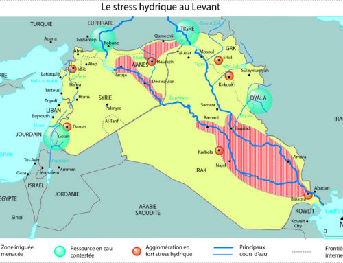
The Atlas of the Near East offers an in-depth examination of the economic, social, and demographic dynamics of the Arab Near East, defined here as Syria, Lebanon, Jordan, and Palestine, in the period from 1918 to 2010. It discusses the central problem of aridity, the effects of foreign domination, Arab nationalism, Baʿathism, and communitarianism. It addresses the make up of the population, the region’s development, economic issues, cities, and urban areas. It assesses the partition of Palestine and the geography of the Occupied Territories, and concludes with a chapter on the geopolitics of the Near East. With numerous maps, charts, and data published for the first time, it is key to a comprehensive understanding of the region.